Saturday, February 9, 2013

Materials + Methods: Bimetallic Strips

In biology, there are numerous examples of systems intrinsically keeping themselves in balance (bonus point: if the word "homeostasis" jumped into your brain, you get a gold star) through feedback loops of various degrees of complexity. Feedback loops, in and of themselves, operate through mechanics that can be simulated or imitated in artificial methods. We see this done everyday in mundane devices, and sometimes it scarcely even dawns on us just how important it is that systems are capable of self-regulation without human input or intervention.

The notion of incorporating this concept into the built environment is something appeals to me greatly, and with any luck, I'll be able to work toward my thesis exploring this notion. However, my research goals aren't the point of this article. It's about creating smart buildings. Structures that can self-regulate critical functions and possibly even due so without requiring power in the traditional sense. Thus, self-regulating buildings represent a particularly inviting paradigm-shift in the modern setting - a structure that can reduce it's ecological footprint and increase efficiency.

I have no doubt that there are other materials that are capable of being applied to this sort of system, but for now, the material I want to talk about are thermo-bimetals, or more accurately, bimetallic strips. These are comprised of two strips of different metals that are bolted, welded or otherwise permanently connected together. Each piece of metal has a different coefficient of thermal expansion, which causes them to act in opposition to one another as the unit is exposed to heat. 

At this point, I think a quick explanation of the mechanics is in order. So, they have two different coefficients. So what? Well, to put it simply, as the metal unit will expand and bend one way if exposed to heat (due to the coefficient of one of the metals) and will contract and bend the other way if cooled to a point below the baseline temperature. Therefore, we have a system that can react in two possible directions based on a gradation of a particular stimulus (heat, in this case).

We see these in use in everyday items such as a typical thermostat, which uses the difference in expansion coefficients to trip the circuit responsible for heating your home when the ambient temperature becomes too cold. Also, the materials used are typically steel and copper, which makes these devices somewhat affordable for any potential architectural applications. 

Speaking of architectural applications, what are they exactly? Glad you asked. Ironically, it's not just a coincidence that bimetallic strips are seen in use in thermostats - they also possess a remarkable potential for regulating the interior temperature of a building. Imagine a lattice or even a wall woven out of bimetallic strips. If the interior temperature becomes too hot, the strips will deform and create an aperture that allows for air ventilation and circulation, thereby cooling the room back to baseline and causing the strips to return to their original state. Boom. Feedback loop. 

It's amazing to see how a biological concept can translate so well into a potential tool for the built environment.

As a caveat, I'd like to say that I have practically zero knowledge when it comes to the statics of these materials or any of the actual engineering parlance and technical jargon that would be required to implement such tools in practical use. But then again, the first step is often simply identifying a potential solution. The details will work themselves out, usually. However, I simply wanted to bring this sort of possibility to the attention of anyone out there with a vested interest in the architectural field. The scope of reality in the built environment is changing just as rapidly as the world around us. Finding solutions that can work smartly, effectively, and yes, as the risk of sounding passe, sustainably, is not necessarily the necessary choice, but the wise choice.

As they say, work smarter, not harder.

Also, if anyone is interested, there is an architect at USC who is doing a substantial amount of research into this concept - Doris Kim Sung. There's a video of her explaining her research and the applications of thermo-bimetals on TED, which I will provide below:


I hope to write additional posts on other unusual materials and methods later in the future, but I figured this would be a good place to start. These are the sort of things that captivate the imagination of both designers and any people that come to a place, I would think. Definitely feel free to post any suggestions about other ideas to explore or take a look into - I don't mind researching new and exciting things.


Sunday, January 27, 2013

WORLDBUILDING: PART 5

N A T I O N B U I L D I N G


When we last left off, we had identified the composition of our world's population(s), but stopped just short of figuring out exactly what sort of countries and nations said people had arranged themselves into over the vague timeline of Dragonsgate. Again, we must plot forward without knowing much about the history of our little brainchild, but fear not, we will get there eventually.


So, what now? We have 7 proto-nations to develop. Right now, they're little more than occupied sites. We need to pay attention to the characteristics of the regions we've already identified (1-7) and also factor in the population choices we decided upon last time. A couple of the proto-nations already have a rough identity associated with them and now all we need to do is hammer out those details. The more defined proto-nations would therefore be the most logical starting point. If we need to make adjustments to their identity/characteristics after fleshing out the remaining nations, then it's a fairly easy process to make minor adjustments/modifications.


Here are the nations we know we have:

  1. Anglo-Saxon nation
  2. Teutonic nation
  3. Iberian nation
  4. Middle-eastern/Mesopotamian nation
  5. Orc/Goblin/Troll nation

This technically means that we have five figured out (roughly), but the remaining two will also have to be figured out, unless it's determined that they're some form of dominion of one of the other five (which is possible). We also know that we have a tiefling city/state to place somewhere as well as a fairie/fey, forest-kingdom to set up, and the location of those areas will be largely determined by the identity of their surrounding neighbors (I believe the the tiefling city-state should be established around the regions labeled as 6 or 7, probably up in the mountains, since they, you know, guard the secrets of magical power and such. The forest between Regions 4 and 6 has my eye as being the potential location for the Fey Kingdom. I'm also thinking that a collection of druidic tribes and other exiles from civilization might have made their home in the large forest the west of Region 4


Also, once we have these nations finalized, we can start naming specific regions and locations so they're not simply referred to by such vague terms as “the northernmost woods” or the “northern sea” or “the large river that runs through the southern desert”. That will make things significantly more interesting, but it's still a little ways off. Climb one mountain at a time and such.


Region 4 is going to be the Anglo-Saxon kingdom. I'd like to keep the Anglo-Saxon kingdom and the Teutonic kingdom in as high a latitude as possible, and therefore, Region 6 is the Teutonic kingdom (and the tieflings will inhabit the long mountain range just to the South). Region 2 is going to be the Iberian nation, and at this juncture, I'm very certain I'm going to model it after Spain, just after the Reconquista. Therefore, Region 2 is going to be modeled after the Islamic Caliphate of Córdoba (or the kingdoms of Al-Andalus) (with its capital modeled after the city of Córdoba itself, (and likely Granada as well) thereby giving it a distinct fusion of Moorish and European medieval aesthetics).

 
La Rendición de Granada, Francisco Pradilla y Ortiz, 1882,
That leaves us Regions 3, 5 and 7. I think Region 3 is a good location for the Orc/Goblin/Troll nation, as it is isolated from the other nations, and it is not too hard to believe that human settlements would distance themselves from such monsters and that such a xenophobic sentiment might be mutual from the orcs/goblins/trolls. Nevertheless, it would also be highly entertaining if this kingdom had a significant degree of diplomatic or trade power to exert on the rest of the civilized world. Maybe they even helped form a treat between the belligerent countries of 1 and 2 at some point. These are some rare chances to add some flare and flavor to your campaign setting – that is to say, finding ways of turning stereotypes (particularly fantasy tropes) onto themselves. You never know how you might create an interesting story element for your campaign setting just by thinking of a simple way to shake things up. It doesnt have to be cleverly inventive; the simple tricks often work the best.


Now, regions 5 and 7. I think that Region 5 should be a seafaring kingdom/mercantile nation that sould be heavily influenced by its larger neighbor to the North (2), but should retain a considerable amount of autonomy due to its economic power. Alternatively, it could long ago have been beset by Nation 2, representing an irresistible opportunity to gain power and wealth (as most economic centres of the world are wont to become). Regardless, the mountains between 2 and 5 are going to be sheer and treacherous and any protracted military campaign across their summits will be expensive and likely to meet in catastrophic failure, so it's a good bet that Nation 5 is independent and safe until 2 can figure out a way to get across the peaks. Right now, Portugal sounds like an excellent precedent to loan to Region 5, and I'll work with that for the time being.


7 is going to be the tricky one. The area is filled with sounds, fords, lakes and other large inlets from the sea, which immediately conjures imagery of a Nordic society; however, as I've already decided that I want 4 and 6 to represent the Anglo-Saxon and Teutonic countries, 7 doesn't really get that option. And I want the Teutonic country to abut the Anglo-Saxon country, so that doesn't really leave too many options. You know. That gives me an idea. Perhaps the Sea traversed by Teutonic settlers from Area 7 and led to them settling in Region 6 and eventually Region 4 before being thwarted moving downward in droves by the mountainous barrier between the northern latitudes and the more temperate central region of the land. That would mean that 4 and 6 were really part of one kingdom, but could reflect two sub-kingdoms, much like the real Anglo-Saxon era England was. I like that notion. It creates opportunities for petty lords and sub-kings to wage their own wars with one another while the King himself struggles to maintain order in his squabbling territories. This also gives the Teutonic kingdom some degree of isolation and could magnify the importance of the mysterious tieflings in their culture. In fact, the more I look at it, there is a large unoccupied island in the middle of the northern sea. This might be the perfect location for the tieflings and their mystical well of magical energy.


So it looks like I've successfully mapped out my kingdoms and regions. Now it's time for some political boundaries, which means more map-making. So, I open up our trusty map again in Photoshop and select the “Overlay” layer that we established a while ago. Firstly, I'll run Edit > Stroke on the inside of the layer. I choose a somewhat conspicuous color – purple in this case (hex 7a2a97) set at an opacity of 70% and a thickness of 5px. It's also important to create a new layer before applying the stroke; I create a new layer titled “political boundaries” and apply the stroke on this layer (we just used the overlay layer to get the correct region selected).

Our layers so far.

The stroke will probably look a bit jagged and unappealing, so just run a gaussian blur filter over it (set to 1px) and that should take care of the problem. Now, it makes the most sense to have 4 be bounded by the rivers surrounding it (rivers have always been important historic borders), so I color those in using the brush, essentially just tracing over the rivers. I decide the southeasternmost boundary will run all the way to the most distal artery of the river, literally abutting the fringe of Nation 2. 

According to my settlement map, this area is very heavily populated and as such, we can conclude that this area is perhaps hotly contested between the nations of 4 and 2, with some of the most economically viable cities of 4 located on one side and the likely seat of the government for 2 located on the other side. Perhaps this border is even a site of continuous battle. Maybe the settlers on either side of the river have seen the land change hands far too many times to be concerned with issues such as “nationality”. It's a possibility. I'll move onto 2 now, as they present an interesting problem – there is no definitive boundary between 2 and 1, which leads to the question of how and why did they determine to have an arbitrary border between the two countries? Otherwise, the borders for 2 are delineated by the mountains that surround it. That's when it hits me; 1 will be a tributary state to 2, much like the real Caliphate of Córdoba became after the Christian kingdoms of Northern Spain beset it. 1 will retain a significant degree of autonomy, but ultimately defers to 2 in political and commercial matters. This also considerably expands the resources available to 2 as a kingdom and is starting to give the impression that it is the dominant power in the Theatre of the Realm here (particularly as 5 serves as a de facto trade outpost/ally to 2 and is all but entirely out of the reach of 4. 4 will likely rely on a steady trade relationship with the Merfolk kingdom that I had mentioned in the previous post. 6 probably trades regularly with 7 and 3 might risk trade with 1; or perhaps there is a trade agreement between the dwarves in the mountain range between 3 and 1, part of an intensive effort to maintain peace and stability in the area (particularly if I continue with the idea of making the Orc/Goblin/Troll nation one of consummate diplomats). For the time being, even though 1 is a tributary state to 2, I create an artificial border between the two regions, mainly for my own purposes at understanding the outermost limits of 2.


After drawing these borders, 5 is already contained within its boundary against 2, 1 and the ocean; and 6 has also been locked into its borders between 4, 2 and the sea. I finish by drawing a border along the river that straddles regions 7 and 3, making that the border that defines those two countries. Looks like our political mapping is done. I make the political lines thicker by running a 5px stroke on the boundaries layer.


As we move forward, I'll drop the opacity on the political boundaries so they don't obstruct the image on the whole; but for now, we need it to visualize how everything is fitting together.

 Political Boundaries


To finish today's post off, we'll start brainstorming fitting names to match with our countries. I've already brainstormed a few that sound quite usable, but even if it comes down to only two potential choices, it still makes it incredibly difficult to pick what an entire nation should be named. I'll attempt to do my best for now, but I'm incredibly picky when it comes to names, so this may be a bit more intensive than you might initially think.


  • Our Caliphate of Córdoba knock-off/tributary state to Nation 2: we need something that has a Moorish or Muslim flare to it but without overtly plagiarizing a real-world source (though obscure ones are acceptable). So far, I've come up with Marad, Arahim, Vasir, Jaffa and Jetar (the latter two of which have a soft 'j' sound as in bonjour). I'm leaning toward Jetar at this point. Though, Marad does also have a very appealing sound to it. I'll go with Marad. In this invented language, I decide that it translates as “Sea of Sands”. The Emirate of Marad? The Caliphate of Marad? The Caliphate of Marad. Done.

     A view of how I imagine Marad to be. I'll search for imagery and scenes that depict the various areas of Dragonsgate later on. Probably in a "World Tour" post of sorts.

  • Our post-Reconquista Spanish nation: I've invented a couple of names that sound fitting – Andujas (I like the resemblance to barajas) and Terrego (I like the use of terra as a root), both of which have an appropriate sound. Also, I like the idea of making the name of the capital city Alatriste, a nod to the infamous Captain Alatriste, main protagonist of the works by Arturo Perez-Reverte (which, if you like swashbuckling adventures, I highly recommend). Not to sound biased, but Andujas/Terrego is already sort of becoming my favorite. In fact, I'm going to name the country Andujas, leaving Terrego to become a prominent city in the land. In this world, Andujas means “Burning Winds” as the hot siroccos from the deserts of Marad and the wastes beyond the oases that sustain the desert kingdom roll over the Kingdom, creating its characteristic temperate, dry, chapparal climate.
  • The Orc/Goblin/Troll nation (which I am getting very tired of referring to it as) desperately needs a name. But that's a lot of different monsters to reconcile with one another, so I might go with a name that can be easily translated into the “Common Language”, something that they would likely always be referred to as by outside nations but would probably disdain themselves (after all, they are, if anything, poorly understood as a nation). After considering this for a while, and remembering that the Region 3 sits upon rapidly escalate to a cold plateau, I decide to call the region Pazu, which literally means “the Plateau” in Orc (yes – I just made that up right now. I don't know orcish. However, there are Tolkien scholars that do).
  • The Anglo-Saxon kingdom needs a name that sounds very Medieval and quintessentially English. As such, it might be a literal name such as Wessex or Sussex – literally West Kingdom and Southern Kingdom respectively. I like the name Windmarch, and I reason that the name alludes to the oceanic breezes that pass over and through the mountains that converge at the peninsula of Windmarch.
  • For our pseudo-Portuguese trade hub, I have it down to the names Ferrago and Contão. Both sound Portuguese, or at least vaguely so. Ferrago sounds the stronger of the two, but I think that Contão should still see service as another city.
  • Following the logic for Windmarch, we'll employ a name that fits to the geographical identity of the country. Seagate sounds like a good name, and appropriate given how important the northern sea is to the relationship between Seagate and the Teutonic nation.
  • Finally, we have only to come up with a name for the Teutonic nation. For some reason, Eindhoven comes to mind. It sounds good and seems to fit with the rough regional identity. Eindhoven it is.
Now we have our country names and we can really start jamming ahead with this campaign setting. Everything from this point is finer details that will serve to enhance the clarity of the setting and make it more servicable for active Campaign Duty. Next, we'll start delving into the history of Dragonsgate and investigating the nomenclature utilized for the rest of the geographical features, such as the woods, mountains, rivers, lakes, seas and sounds.


The current map looks very bleh, in my opinion. But that's mainly because it's meant to illustrate a few crucial pieces of information at this point, all of which are easily hidden or removed as necessary. Anyway, here's what we have so far:


Cheers until next time!


Saturday, January 26, 2013

WORLDBUILDING: PART 4

T H E   P E O P L E   O F   D R A G O N S G A T E

There's a lot to be covered when it comes to the people and civilizations that occupy any world you create. Not only does the interplay of various cultures create the possibility for intense conflict (which can be rich fodder for a campaign or story) but it also implies an intricate drama of history that has taken place over the ages (which can also fuel plot-points for a story in addition to layering more realism to your nascent world). It's this dynamic that needs to be carefully considered. Often, in my campaign worlds, the only major race found across all continents is the human race. These are usually based off of different real-world cultures (as we'll see below), but sometimes it's not as easy as that. For the Dragonsgate project, we've been trying to incorporate a more traditional/canonical experience, and this obligates us to include at least some of the stereotypical fantasy races (ie. Elves, dwarves, gnomes, halflings et al.). Each of these additions forces us to consider just how that race plugs into a niche of civilization, requiring its own history and purpose.

Some designers assume that a utopian panoply of creatures and peoples have meshed into a hegemonic civilization at some point in the world's history. There is nothing wrong with this approach, though it may strain the ability to be credible. There certainly is no wrong way to populate your world – it's your world after all. Do what seems the most fun (or whatever best suits your design intentions). 

The first step I take in figuring out what kind of people inhabit Dragonsgate actually involves skipping over the history or what kinds of creatures and people I want to see in the pages of the campaign and instead looks at the areas of the world (or the part of the world, in our case) that would be the most logical places for the seeds of a culture to take root. I look for areas that have natural fortifications (ie. Surrounded by mountains, elevated on a plateau) or advantages that would help facilitate city-growth, development and/or commerce and trade (proximity to rivers or the shores of the sea). Areas that would be inhabitable are also marked as points of interest – a culture might not flourish in a location, but that does not mean it might not be settled. For example, in Frank Herbert's Dune series, the desert-dwelling Fremen by no means have a super-complex, thriving society in the barren wastes of Arrakis, but they do manage to survive, albeit through highly disciplined efficiency. That said, I'd prefer to focus on areas that are “cornerstone” locations for a Civilization, not a tribe here and there. In general, the larger details are the ones that you need to know in advance prior to beginning a campaign. A kingdom or a race, a large city etc. A tribe or a singular encounter with a small, primitive culture could be an excellent idea for a single session within a large campaign, but it is a small enough detail that it doesn't warrant exhaustive preparation prior to the onset of the campaign. Essentially, I don't need to factor it into the design of the campaign setting inititally as it is a small enough detail that it can be inserted at ease later. That's not to say that small details are trivial or unimportant for a campaign. I merely suggest that the smallest details be saved until they prove necessary, as your task in worldbuilding is already difficult enough.

On our map, I use the circular marquee tool to select the “regional hotspots” where the critical settlement locations will be (ie. Likely the capital cities). I create several concentric or semi-concentric circular selections around this first main selection, each the same color but at a lower opacity than the preceding circle. This gives some insight to the level at which civilization will taper off as you move away from the heart of the settled lands. If you notice, the main settlement regions also correspond nicely to the regional locations that we roughed out previously (Regions 1-7). Following this graphic representation, it will be convenient and somewhat more easy if each of these regions corresponds to a kingdom or country (or territory of another country). I'll follow that system for now, and if any sudden bursts of enlightenment strike me, I'll revise as necessary.


At this stage, knowing nothing or very little of the history of Dragonsgate, making a shortlist of the races and creatures I think would make viable candidates is helpful. The history of the world is important, but if I don't know who or what exists in the world in the first place, I can't begin to understand the events that have happened in the past. This would be a tremendously difficult task to undertake, and working from ancient history to the modern times is often an approach solely employed when building your world with the macrocosmic method.

This list will help me begin to brainstorm the main reasons for including each race/creature. I'll move back through this list and evaluate whether or not there is space or potential for each society to function in a way that is usable for a typical campaign or series of campaigns. Over time this list could change considerably, but we need a place to start.

  • Humans: a bit of a no-brainer here, as humans are essentially the bread and butter of any fantasy world (though they don't need to be). Just like the real world, humans exist in a range of ethnicities, and that will hopefully be reflected even in our small subsection of the world of Dragonsgate. I've already had in mind for a while that I want to model one particular region after an Iberian country, such as Spain or Portugal (Likely taking root in Regions 2, 5 or 1, but most probably 5). Additionally, I've been interested in developing an Anglo-Saxon (England prior to the Battle of Hastings) society or perhaps a Teutonic one (that remains to be seen yet). That (or those) nations would probably end up occupying Regions 4, 6 and/or 7. Ultimately, regions 4 and 6 might be the same country, though I think the major river that separates the two regions would probably act as a serviceable barrier between two countries.
  • Tieflings: I'm a fan of humans that have a line of ancestry tainted with diabolical influences. While such individuals are not necessarily evil themselves, they are often prone to such personalities. When I was first beginning the initial steps in this project, I had thought it would be interesting to have not necessarily a country of tieflings, but a city of tieflings that housed or hoarded some sort of knowledge, wealth or power that was kept a closely watched secret form the rest of the mortal world. I had also toyed around with the idea of a low-magic setting, as my usual settings are often flush with magical energy. The tieflings could be protecting a wellspring of magic that acts as a bottleneck for mortal spellcasting. Already, I'm envisioning that the tieflings keep watch over a well of mystical water, such as the Nordic Mimir's Well ( For Your Information) which was responsible for bestowing omniscient knowledge unto the god Odin), where mortals come to endure a treacherous path that can ultimately lead to their chance to drink from the well and gain mystical powers. The mythical Mimir's Well required that an appropriate sacrifice be made (Odin gave one of his eyes, for example), and perhaps that could be integrated into the concept as well. Regardless, Tieflings are in.
  • Aasimar: just as the tieflings have a dark bloodline, there are humans whose bloodline dates back to some source of grace or celestial ancestry. I think it would be perhaps a bit too symmetrical to have a city of Aasimar that balances the tieflings. However, there could be one lone Aasimar that has undertaken some great duty, much like the lone crusader knight left charged with protecting the Holy Grail in Indiana Jones and the Last Crusade. Something to think about. It's a bit more specific than any other race included, but it could create an interesting plot-device at some point.
  • Elves: at one point in my life, I was fascinated by elves. I considered it my Tolkienesque phase. Nowadays, I rarely plug a major elven civilization into any setting (usually excluding them entirely), and this will be in keeping with that design choice. In one of the major forests in Dragonsgate, there will likely exist a transitory kingdom of fairies and fey that ebb and flow between the plane of Dragonsgate and the plane of Faerie (I'll discuss the cosmology of Dragonsgate in a later post). This fairie kingdom will probably include elves, satyrs, nymphs, pixies and sprites). I might even venture to call it Titania (after the fairie queen in A Midsummer Night's Dream) – I do like to punctuate Shakespearean names into my works often. The man had good taste in naming characters and places, in my humble opinion. So, elves are in, but in a limited fashion.
  • Dwarves – I'm on more amenable terms with Dwarves, but I strictly believe that they would scarcely care to venture above ground and away from their mines, and as such, their influence is almost entirely limited to the subterranean world. Occasionally one will find his way out into the surface world and find work as a mason or a master craftsman, but it is rare. Nevertheless, dwarves are universally expert artisans and expert practitioners of any craft they have set themselves to. Dwarves make the cut, but they won't be factored into any of our established regions, as none of these eke out territory underground.
  • Gnomes – I don't particularly like gnomes. The reasons are hard to justify, but I have to concede that they do serve a useful niche as tinkerers and machinists. Granted, the technology level of this world isn't too far advanced and the thought of a people out there capable of introducing intricate war-machines or scientific devicery is a bit troubling. I'll say gnomes exist, but guardedly. Probably in small, isolated collectives. Or perhaps they are also limited to underground settlements.
  • Halflings: I like halflings a great deal, though I usually never see them played in a campaign, nor do I see them employed in most settings (though it's never implied or stated that they don't exist per se). Also, it's unfortunate that the stigma with halflings seems to insinuate that whatever setting they find themselves in is trying to emulate the Lord of the Rings or the Hobbit. I would argue that this is a logical fallacy, mainly as the works of Tolkien are seminal texts in forging what can be considered the modern fantasy genre. Nevertheless, I understand that many worldbuilders refrain from using the smallfolk as it seems to undermine the sense of enterprise and ingenuity that all designers wish to feel. As I want this world to feel canonical, but also very medieval, I will not say that halflings do not exist, but I will not detail any regions or areas that are predominantly halfling in composition.
  • Orcs and Goblins: Both are in, mainly as they serve as quintessential baddies. However, in light of that, I'd like to break that stereotype, at least a little bit. They often are portrayed in tribal societies, sometimes as “noble savages” (such as in the Warcraft world (at least starting with Warcraft III – anything prior to that definitely lumps the orcs into the “bloodthirsty monsters” pile). I'm thinking that a more polished city-state or feudal society in which the orcs rule with an iron fist and the goblins are relegated to slavery (or serfdom) could be interesting. Alternatively, the orcs and goblins of the world could simply be servants of the tieflings aforementioned. I'm not too sure yet, but I'll say that both orcs and goblins are in. Hell, I'll throw trolls in here, too. In fact, I might try to make a nation with a rigid caste society in which orcs, goblins and trolls stand atop one another.
  • Giants and Ogres: given the relative abundance of mountainous terrain in our areas of interest, it seems logical to fill those highlands with monsters typical of such biomes. They're usually solitary or tribal, and there are all sorts of varieties of them, but as they're mainly relegated to the highest reaches of the mountains, they won't really factor into our Regional scheme, although they would logically present some existential complications to the dwarves of Dragonsgate.
  • Merfolk: I've been fascinated with the notion of having a human kingdom that trades regularly with a peaceful merfolk kingdom situated off the coast some distance. It just strikes me as one of those fun, fantastic elements that we can get away with just because. I like the notion. Merfolk are in. But if they start collecting snarfblasters and dinglehoppers or talking to seagulls, there might be some problems.
  • Outsiders: Celestials, Devils, Demons, Genies. I tend to overuse outsiders, mainly as one of my absolute obsessions in the fantasy genre is the notion of a multiverse or a multiplanar worldweb – a collection of infinite or near-infinite worlds and dimensions that are connected together by some sort of cosmic fabric and almost always only accessible via magic. I think one of the quintessential examples of this method of setting design is accomplished in the card game Magic: the Gathering (the notion of planeswalkers and such). Granted, this can make for some fantastic story elements, but as it does tend to distract from the more canonical feel I'm aiming for, I will say that none of the nations in Dragonsgate will be purely for outsiders of any kind. That said, I do feel like using Genies, as they are a type of creature that I employ relatively rarely, and they can be very fun. They evoke a great deal of unusual but highly intriguing exoticism, which make them a striking element for a nation or place that needs to feel decidedly different. I'm not entirely certain if I want to have a nation that takes inspiration from the Middle-East, but with one of the potential nations resembling Spain/Portugal, it would make sense for that country to fuel a geographic transition to a place that derives elements from Syria, Jordan or maybe a more ancient civilization such as Babylon, Sumeria or Assyria. These kinds of details will fall into place as we move into Nation-Building.

Now that we have the kinds of inhabitants fleshed out for Dragonsgate, we can determine how they are organized. We have Nations 1 – 7 to identify and elaborate upon. Our seven Proto-Nations will be where we pick up next time, as it will probably prove to be a somewhat tedious task.


Wednesday, January 23, 2013

Work Hazards

Just something to fill in the gap until Worldbuilding Part 4 is posted in a couple of days.
Enjoy!

Monday, January 21, 2013

WORLDBUILDING: PART 3

In this post, we're going to get the forests and mountains (actual mountains) added to the map and start discussing the climates in the regions of the world as well as start thinking about the specific biomes represented in these areas.


For forests, I usually use a brush with a spatter appearance (I've included a screenshot below with the pixel size highly exaggerated to give you a better glimpse of the specific type). I find that using a brush size of about 30px is appropriate, though to get the best effect, using a variation of brush sizes in the forest is ideal (hint: using the [ and  ] keys is a shortcut for decreasing and increasing the pixel size of your brush, respectively).


As for the placement of forests in the world, I don't have a clear understanding of the wind circulations for the planet (there's not enough information about our planet to determine the coriolis forces acting on the atmosphere), but because I know that this region of the planet isn't too close to the equator, it's a safe bet to say that there will be at least periodic winds coming across this landmass. Therefore, it's important to pay attention to the rivers and the mountains that I've arranged so far, because the mountains will determine the severity of any rain shadow effects (see the link below), and while not all rivers would encourage significant tree growth along their course, some definitely will (just think of the Amazon River).


That in mind, I decide that I would like to see a coastal forest in the Northwestern region, just to the West of the mountain range there and abutting the river that runs from the north to the ocean there. Additionally, I know that I would like a temperate forest to sit at the fringes of the desert region in the southern-central part of the map, so I brush that area in. I realize that it might be difficult (biologically) to explain the presence of the forest there, but as this is a fantasy world, some liberties can be taken. Maybe it's magical. I've already been tossing around the idea of a realm that acts as a sort of Casablanca for feys that have been displaced from their native plane of Faerie. It could be fun working in some sort of mechanic later as to perhaps how the forest is magically sustained by dryads or nymphs or somesuch. There's also a decent river that runs from the East to a pair of smallish lakes just south of the large sea. I decide that I like the idea of strong winds funneling through the gap between the two mountain ranges that converge at those two lakes, and as such, it seems like a good idea to have a high altitude forest here, fed by the winds blowing over the sea and the lakes and the river that courses past it – in fact, I think this might be an alpine plateau (possibly), but that remains to be seen. Later, I'll figure out the specifics of the climatic zones. For now, I dot in some other forested regions here and there, mainly just to add some points of interest in other zones. Some of these small forested regions might harbor specific details that will be worked out later in the design process on the whole.


To finish with the forests, I add a black stroke to the outside of the contents of the layer. Set it to 3px and to an opacity of 75%. This will give the spatter pattern put down earlier a nice shadowy, layered look that looks pretty nice, in my opinion.


Now, returning to the mountain ranges, I'll use a triangular shaped brush to represent the mountains. You can also paint divergent lines from the lines we drew before (the ones representing the highest altitude along the range) which would simulate the wrinkly look mountains have when viewed through a satellite image. Given that the whole purpose of the map is to look somewhat more antiquated, it would defeat the point to use a method that would end up presenting the map as more modern. So, for my map, I stick with representing mountains as triangles of different sizes. It's a little inaccurate, but it works. For the brush, I use a smattering of sizes, with the largest triangles following the line representing the highest altitude and with smaller triangles clustered around this main line. I don't want the area to be saturated with mountains, so these ranges are relatively “sparse”.


After the mountains are in, I'll go back and delete the red guidelines I drew in before. You can also add a stroke at 3 px and 85% to the mountains – it helps tie the whole image togeher, as we've added a lot of pseudo-inky looking qualities to the map so far.


Before moving on to anything else, I think it's about time to at least add a little color to the ocean/seas, if anything just to tie the image together better. I change the white layer to hex 9ba997, which gives it a brownish blue coloration that fits with the Age of Exploration thing we have going on here.


Now, on to climates. As mentioned before, the southern-central area is a desert. I don't think the entire area is one rolling sea of dunes or anything along those lines, and there will definitely be a gradation between the aridity of the biome. I'm thinking that it will be a rocky desert toward the center with a cluster of more Mediterranean Chapparal regions clustered around the periphery. Temperatures in this area will be more mild and temperate, whereas the climate will be more severe and hot in the center. I'd like one of the countries in this land to be pseudo-Iberian, so this will work out nicely. With one major area hashed out, that really only leaves the northwestern region, the eastern region and the northeastern regions unresolved.


Our map is approximately 10in by 14in (landscape orientation), so, with our established scale in mind, that of 0.25” = 10mi or 1” = 40mi, we can say that our map is basically 400mi by 560mi. 600 miles is a paltry sum as far as latitude is considered, so it would be a stretch to say that there will be a huge amount of climatic variation in this part of the world. Again, this is fine, as the extreme areas will be a dry rocky desert topography and a more temperate Mediterranean climate. It may also be a bit of a stretch, but I am tentatively thinking that the land between the two mountain ranges that converge in the East is of much higher elevation than the rest of the landmass, and therefore will be much cooler.


I also think that it's somewhat safe to say that this map represents part of this world's Tropic of Cancer, assuming that the orbital and axial characteristics of the planet are not too dissimilar from Earth's (I know that this information was generated by the fractal map generator back when we started, but given that I cannot speak for the implications of having a planet with such widely different tilt or size, it seems best to not deviate too far from Earth. As a matter of fact, for this series, I'm entirely disregarding everything that the fractal map generated, apart from the region I selected). So, the southernmost points of the map are at least partially inside the Tropic of Cancer (or on the fringe), and as such, are likely either subtropical or temperate in their climate characteristics (depending exactly how far north the latitudes for our map region are – which is largely a matter of creative fiat at this point). We won't go into wind patterns and Coriolis effects, mainly because that level of meteorology and atmospheric detail is getting a bit too dense for our purposes here. We want something that is believable, but not necessarily entrenched in realism. It is a fantasy world, after all.


After considering all of this information, I've grouped the map into the following climatic zones: in the southern portion of the map, between the two ascending mountain ranges, there is a dry, rocky desert biome (1); north of the desert and in the mountainous areas immediately surrounding the desert, there is a more mild, Mediterranean clmate, filled with a chaparral ecosystem and complete with a large temperate forest in the center. It's logical that precedents from Greece, Rome and the Italian Republics could be used for inspiration to fill the aesthetics of any countries built in these regions (2). However, I think that one of the largest nations in the area will be modeled after Iberian precedents, and transform to something pseudo-Syrian at the bottom-most region of the desert; the area between the two mountain ranges in the East seems to be a natural location for a valley, perhaps a glacial valley at one time in the geological history of this place, but I like the idea of the valley starting off at a lower elevation in the southeastern region and increasing its overall elevation as you move north, gradually becoming more of a plateau or highland, and therefore susceptible to colder temperatures, probably compounded by the amount of offshore flow from the northern sea. The reason for this is mainly to break up the otherwise homogenous climate that would prevail in this area (that is to say, I don't want the entire map to be a desert or pseudo-desert, so this dramatic change in elevation is an artificial means of creating the variation that I would like to see in a campaign setting). Thus, the area marked as (3) is probably something akin to sub-alpine Italy, with a mild climate that dramatically changes with increased altitude as you move toward the Northern mountain range; therefore, the area marked as (7) (and to a large extent, probably area (6) as well) would be more of an alpine region prone to colder prevailing temperatures and harsher winters. 

Actually, as I think about real-world precedent, the northern sea would be analogically similar to the Black Sea, and as such, area (7) could mark the transition into a decidedly more Slavic region (to use modern analogy), and as such, I will probably reference Bulgaria, Romania, Ukraine and Georgia in looking for precedents and other inspiration for the ethnoculture to fill the region. So far, these regions are fitting well with what I would like to see as far as variation and dynamism are concerned, but also as far as what I would expect given that this region isn't too far removed from the Tropic of Cancer (ie. The real-world Black Sea is at approximately 44 degrees N and 35 degrees E on the globe). To further justify the proximity of our desert region to the pseudo-Black Sea region, just look at a map of Earth – Syria is not too far from the Black Sea. As such, both of these elements are not too far removed from the Tropic of Cancer, so I think that by arranging our climatic regions as such, we are preserving as much realism as possible. The question is: how much do we adhere to the ethnocultural precedents from the real-world analogues that we've discussed? It's really a matter of creative fiat as well. Granted, I'm running away with my logic, so I'll try to dial back into the basics here. That leaves regions (4) and (5). Region (4) will be rocky plains bounded by the mountains to the west and south as well as a significant amount of wooded area; it will be temperate as well, with a moderately cold winter and a warm summer. 

On the western side of the mountains, the temperatures will drop again, producing a cooler alpine region, and I think I'll model this region after Anglo-Saxon culture, mainly because I want at least one region to have something based on the more “canonical” elements of a fantasy world, that is medieval European (specifically English) elements. Lastly, area (5), probably buffered from the hot, dry winds of the desert by the Southwestern mountain range (much in the same way that Area 4 and 6 are shielded from the sirocccos), would also be a more temperate, fertile region, given the proximity to the shore and the prominent river that runs through it. I think that this area will probably be a holding of the Iberian nation that exists to the north over the mountains. Although, mountain ranges do usually make for ideal borders between countries – so maybe it will be a principality, suzerainty or somesuch relationship to Area 2. That remains to be seen and will be something that we will begin to discuss next time.
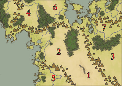


Well. That was a long one, and I think this is where we'll call it for the day. So far, we have a strong understanding of the climatic zones and what sorts of real-world details can be extrapolated to our new world. Next time, we'll look at how these regions are divided up into nations and states and what those nations and states are. We'll also look at some of the fundamentals of a campaign setting, such as the prevailing level of magic in the world, as that will influence how the countries of the world came into being as well as influencing their relationships with one another – militarily and diplomatically.